|
||||
| Also available as an Acrobat File | 

|
|
Case Studies |
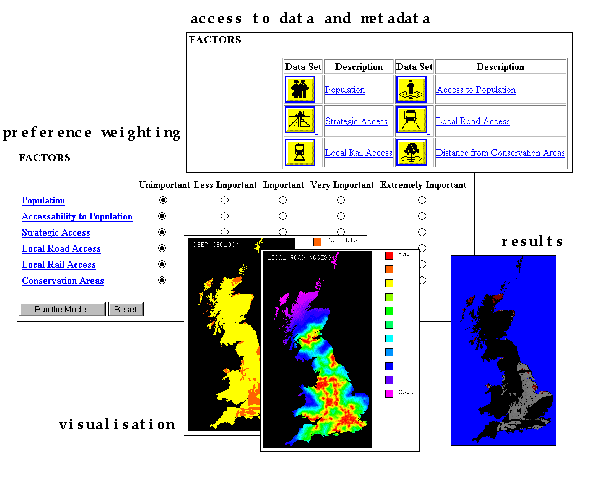
Review of graphical environments on the WWW as a means of widening public participation in social science research4.4 Case Study 4: Where to Dispose of Britain's Nuclear Waste, School of Geography, University of Leeds.This case study provides an example of social science research into public perception of a difficult and thorny issue, that of where to dispose of nuclear waste in Britain. A simple GIS-based decision support system has been set up on the WWW to give public users access to relevant datasets and the tools with which to explore the spatial aspects of the problem and arrive at an informed personal decision. (Carver & Openshaw, 1995).The political risks in developing a new radioactive waste disposal facility are high since no government is likely to win votes on the strength of it. Previous attempts to find a site for the nation's growing stock pile of radioactive waste has shown local people to be strongly opposed to any plans for a disposal facility in their area. This often referred to as the NIMBY (Not In My BackYard) syndrome and has led to vociferous and highly politicised anti-dump campaigns. As a result a number of potential sites have been dropped just before general elections. To make matters worse, the geographical problem of finding a suitable disposal site is accentuated by the small and densely populated nature of the country. IAEA siting guidelines (1983) state that any disposal facility should be within an area of suitable geology, remote from areas of high population, easily accessible and outside of designated conservation areas. The geography of Britain makes this a particularly difficult problem since their are few suitable geological environments and the areas remote from population are generally remote from access and, more often than not, designated as conservation areas. Thus, the relevant siting criteria are conflicting and therefore require careful analysis. Clearly, radioactive waste disposal is an important and controversial problem, and as such attracts a high level of interest. This makes it an ideal vehicle for investigating public response to web-based decision support techniques. Radioactive waste disposal is also an extremely difficult problem; it is political, it is geographical, it involves multiple, often conflicting criteria and it involves multiple stakeholders. The web site also is designed to investigate some of the social aspects of these complex issues. A simple decision support system has been developed to address this problem already (Carver, 1991). This suffers from the fact that it runs only on a stand-alone PC and so is isolated from potential users and interest groups. The system developed here applies the same exploratory decision support principles but on the WWW. This immediately makes it accessible to a global audience and increases the participatory element. The web-based system is controlled via a simple, easy-to-use GUI of hyperlinks, buttons, check-boxes and sensitive maps. There is a high graphical content as demanded by the largely map-based information content. The system is accompanied by a comprehensive information system of hyperlinked text and graphics that provides the user with a full and unbiased view of the nuclear waste disposal problem. Using this, the user is invited to brush-up their knowledge of the problem before entering the decision support system.
Figure 4.3 Selection of images and interfaces from Carver et al. nuclear
waste disposal decision support system The decision support system itself consists of 5 basic steps:
The user is first asked to make an initial choice as to where they think might be a good location for a nuclear waste disposal facility using the mouse to point to this location on a sensitive map. They are also asked to state how certain they are of their choice (i.e. was it a guess or a confident decision). This information is stored for later use and is taken to represent the user's initial perception and understanding of the siting problem. After making an initial siting decision, the user is asked to explore the relevant datasets pertinent to the siting problem. Each dataset is presented in map form with a linked description explaining why that particular dataset might be of importance, its source and what operations have been carried out on it to get it into its current form. Giving the user access to the relevant datasets allows them to familiarise themselves with the multi-faceted and geographical nature of the problem. The next thing they are asked to do is make personal choices about which datasets to include in the site search process and how to weight them in order of importance. This site search model used performs two tasks; a series of binary map overlays using datasets chosen by the user, and a simple multi-criteria evaluation (MCE) routine based on datasets and weights specified by the user. The results from the model are displayed as a map showing good and bad areas for a disposal site based on the choices made by the user. If the user is unhappy with the map produced, they can return to earlier stages in the system and re-specify their choices. If the user is happy with the map as it is they are asked to indicate a for a second time where they think might be a good place for a disposal site and how certain they are of their decision. This information is also stored for later analysis. This final choice is assumed to have been made on the basis of a better understanding of the geographical aspects of the siting problem. All the menus are very easy to use and full instructions and explanations are provided as appropriate. The decision process outlined by the system is prescriptive (i.e. the datasets are provided for the user and only one model can be used), but is flexible in that the user can step backwards through the web pages to any previous stage and review the data or alter selections made. Before leaving the system the user is invited to fill out a profile questionnaire containing categorical questions pertaining to age, gender, occupation and postcode. From a social science research perspective this web-site provides several interesting pieces of information. These are as follows:
The full access logs generated by the web-site, showing the route through the decision support process and choice made along the way, may also help provide more insights into the way that people use information and make difficult decisions. |
Graphics Multimedia Virtual Environments Visualisation Contents