
|
||||
| Also available as an Acrobat File | 

|
|
Editorial Assessment |
The Visualisation of Area-based Spatial Data 4. Assessment of packages4.1 cdv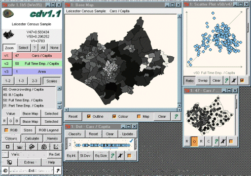
4.1.1 FunctionalityThe bulk of cdv's facilities consist of graphical tools for viewing data, including a wide range of mapping options (choropleth map, point symbol map and cartogram) and some traditional statistical graphs (dotplot, histogram and scatterplot). The system will handle missing values. Most of the facilities are aimed at the exploration of non-spatial elements of the data. Exploration of spatial patterns is done by the linking of the graphs with the map, rather than by specialist spatial graphs or tools. The exception is a facility for exploring the rough properties of the spatial data, through the use of a local Moran's I coefficient. Once this tool is in operation, the selection of a polygon on the map produces a display of the value of the coefficient, and a graphical display of the relationship between the value in the selected polygon and its neighbours. We found this display difficult to interpret, and the purpose of this tool is not clear in the context of the rest of the system. A marked feature of the package is the ease with which the graphical displays can be created and manipulated. Maps are shaded in a greyscale by default, but alternative colour schemes can be set up. In addition, multiple variables can be displayed on the map by assigning them to one of Red, Green or Blue. For those unfamilair with such maps a graphical key is provided to help interpret the resulting colours. The statistical graphs do not have labels on the axes, although the data value for any given area is automatically displayed in the main menu window whenever the area is selected with the mouse. A particularly nice feature is the option of viewing a choropleth map and a cartogram of the same data at the same time. The key weakness of the choropleth map is that the size and arrangement of the areal units has a strong influence on the look of the map - an area which has a `high' value for whatever is being mapped will be far more noticeable if it happens to be large than if it is small. One solution to this is to produce a new set of areal units, where the size of the unit is related to its `importance' rather than its physical extent - this is usually done by relating the size to the number of people in the area. The problem is that this distortion of the geography can make it difficult to interpret the resulting map, since areas may have to be moved away from their true geographical location to `make way' for more populous areas. By having a choropleth map and a cartogram on-screen some of these problems can be reduced, since it is possible to discover the true location of any area on the cartogram by clicking on it and seeing where it is located on the choropleth map. This is an excellent example of how interactive graphics can simply adopt methods developed for paper maps, but help to overcome some of their design problems. 4.1.2 Ease of UseThe initial attempt to use cdv was hindered by the fact that the version at MIDAS has no help information, although it does have a very useful tutorial guide. It was therefore possible to get started, but then became rather difficult to explore what many of the options and menus did. The version on the CD-ROM did have help information, although not the tutorial, and this was helpful for the new user. 4.1.3 ImplementationThere are two versions of cdv - one which may be freely downloaded from the MIDAS web site (address given in the appendix to this report) and one which was provided to us by the author (Jason Dykes) on CD-ROM. Both were installed without difficulty. An interesting feature of cdv is that it is written in a scripting language Tcl which has a windows interface called Tk. Since the implementation inlcudes Tcl/Tk this means that an individual user could modify cdv if so desired. There was not time during this study to assess what skills would be required in order to learn Tcl/Tk and to understand enough of the structure of cdv to be able to add new facilities. Data input is via text files, which can be fairly easily generated from a spreadsheet package. The geographical data is again supplied in text format, which can easily be generated from ARC/INFO. In order to read different files however, it is necessary to edit a parameter file to inform cdv of their existence, which is rather clumsy, and not what users would expect. |
Graphics Multimedia Virtual Environments Visualisation Contents