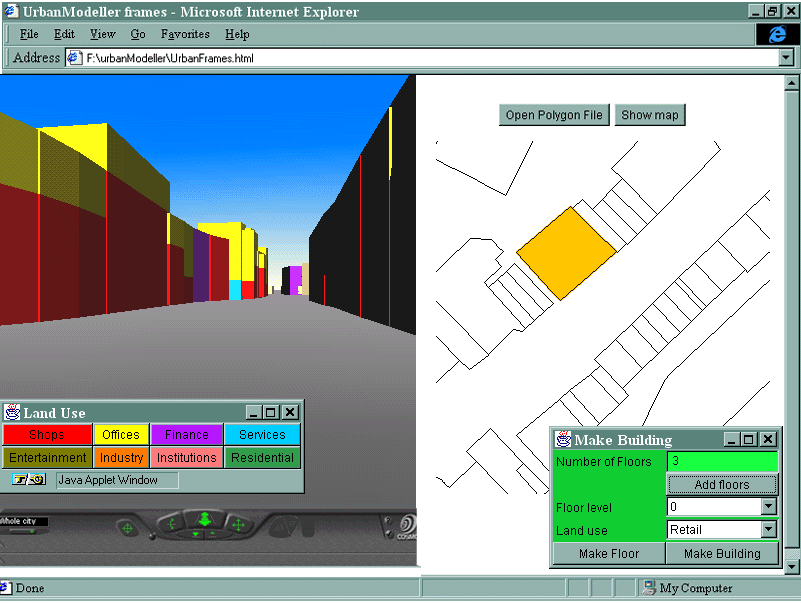
This graphic is a composite of software
currently under development. It shows an interface for interactively creating
VRML urban models from 2D building plans and user input of land use by
floor for each building.
The VRML model is georeferenced for subsequent
tracking on a map interface and external spatial database linking. The
small Java interface on lower left switches colours on/off and provides
a key for colour values.
Animation surfaces are also planned to
display pedestrian space-time movements through the street scene (not shown
here but hopefully available for the workshop!)
The research/teaching problem it addresses
The software is being developed in conjunction with the Virtual Field Course (VFC) project to provide IT support for fieldwork teaching. Visualisation and virtual reality are being seen as key components for integration into this teaching format.
This example focuses on a specific fieldwork project where students survey land use and pedestrian movements within the urban environment.
Land use mapping has previously been undertaken on a 2D map basis which is highly inappropriate for the essentially 3 dimensional character of towns and cities.
Pedestrian counts are recorded at street
level only. Again students normally only have the facilities for producing
static representations for this essentially dynamic event.
How it helps solve the problem
Virtual reality provides new dynamic, interactive
methods for visualisation in 3 dimensional space.
The urban model is constructed as a 3D
thematic representation that can more accurately help to visualise the
functional characteristics of the urban scene. Users can move freely through
this new representation of reality and view it from any angle.
Students gain a greater engagement in the fieldwork project from construction of the model and subsequent interaction. The full model may be constructed by combining component parts produced by individuals which establishes a degree of collaboration in the project. A fuller interpretation of urban structure can be gained from the model through analysis of the 3rd dimensional component.
Space-time simulations can give a deeper understanding of social patterns and the dynamics involved. Using VRML animation students can identify the spatial properties of the city business district and the relationships between the CBD and human movement through time.
The ability to visualise and interrogate
spatial movement within VR offers a new thread of research into the patterns
of population dynamics within the urban environment. Potential applications
include retail and advertising site analysis and urban planning.
Tools used in its creation.
Virtual reality models are built interactively using the Virtual Reality Modelling Language (VRML) in conjunction with the Java programming language through the External Authoring Interface (EAI).
The VRML model runs in EAI compatible VRML plugins (CosmoPlayer, WorldView) for standard web browsers: Internet Explorer or Netscape.
2D plans are imported from Arc ungenerate format.