|
||||
| Also available as an Acrobat File | 

|
|
|
Visualisation in the Social Sciences WorkshopShow and TellBen White | |
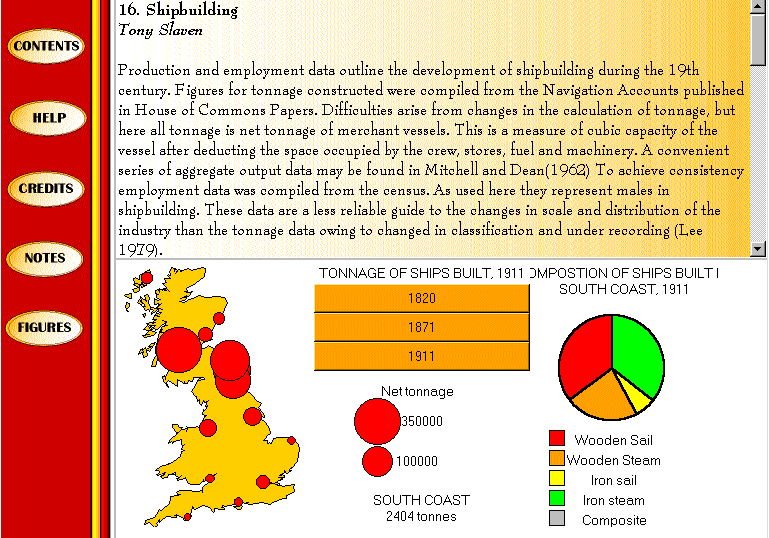
Building a prototype electronic atlas using Tcl/TkFor the last two years I have been working on a JISC JTAP funded project titled 'Authoring methods for low-cost electronic atlases of change and the past'. In broad terms this work has involved a review of potential file formats for electronic atlases, ranging from static bitmaps, through animated movie formats, like MPEG, to fully interactive dynamic mapping using Tcl/Tk and Java. The potential of these formats has been tested in a prototype electronic atlas. This atlas was based upon an existing paper atlas, the Atlas of Industrialising Britain (Langton and Morris 1986). It was hoped that by replacing existing maps with our own visualisations but leaving the existing text we would be able to test potential file formats on real students during their normal learning experience.BACKGROUNDThis work stems from the realisation that there is no effective means for publishing map based research. The traditional publication form, paper atlases, have become too expensive to produce. Major commercial atlases, such as, the Times Atlas of the World costs Ł85.00. In the academic market, attempts to keep costs and price low have resulted in small page, black and white atlases being produced. In practice colour has all but disappeared from the medium of the academic cartographers. GIS based atlases have been suggested as an alternative. GISs however, are too expensive, they require a higher degree of user skill and require the distribution of boundary and attribute data to the user (with all its associated copyright implications). This centered our research on low cost alternatives, most obviously the web.SUBMITTED GRAPHICMy submitted graphic is actually the prototype electronic Atlas of Industrialising Britain. Although, this is significantly more than one graphic it represents a clear problem and research conclusion. In particular the chapter on Shipbuilding extensively uses Tcl/Tk to enhance the map based information.
http://www.geog.qmw.ac.uk/aib/chap16/format16.html (Please note: the Tcl/Tk plug-in will be needed to view the site) This page loads the standard user interface of the electronic atlas. Visible are three frames, the left frame is used for basic navigation through the atlas. The top frame contains the original text of the atlas. This has been enhanced by hyper-linking the figure numbers to load the corresponding figure into the bottom frame. When the page is loaded the first map referred to in the text is loaded into the map window (This represents my one graphic submitted). In this case the map is of shipbuilding production, 1820-1911. The user can select the year they wish to view by clicking the mouse on the dated buttons. This automatically changes the circle sizes on the map and updates the map legend. As the user moves the mouse over the circles on the map the name of the place and the exact tonnage built is displayed in the tclet. If the user clicks on any of the circles a pie chart showing the type composition of the ships built is displayed. (N.B. In 1820 all the ships built were wooden sailing ships and consequently all the pie charts are completely red.) This work is an adaptation of the cdv work of Jason Dykes (Project Argus). Our work differs from cdv in two major ways. Firstly, we are providing a teaching resource not a visualisation toolkit. Secondly, our work is designed to be made available over the web. These two differences necessarily required us to simplify the number of options available to the user, in the first instance to improve usability for untrained students, in the second instance to reduce the amount of code in the example and consequently, the size of the file that has to be transferred across the internet. This example represents the tip of our research covering visualisation of historical (time series) data, electronic atlases and the effective dissemination of map based visualisation research in the academic community. Contact DetailsBen White,Email: B.M.White@qmw.ac.uk Department of Geography, Queen Mary and Westfield College, University of London Telephone : 0171 975 5397 |
||
Graphics Multimedia Virtual Environments Visualisation Contents