
|
||||
| Also available as an Acrobat File | 

|
|
|
Visualisation in the Social Sciences WorkshopShow and TellJackie Carter | |
Visualization Tools for the Exploration of Census Data : the Cartographic Data Visualizer (cdv) and DESCARTES1. Introduction to exploration of area enumerated census data setsMIDAS (Manchester Information Datasets and Associated Services) hosts a number of large and complex strategic datasets for use in the UK academic community. These include the Census of Population area based statistics and the associated digitised boundary data. The KINDS (Knowledge-based Interfaces to Spatial Datasets) Service, hosted at MIDAS, seeks to support users of spatial data, regardless of their level of expertise. Spatial data is hard to use. Census data is voluminous. A current JISC-funded project at Manchester Computing is developing and supporting software which will enhance the KINDS system by creating a Visualization Gateway to the Census Datasets held at MIDAS. This will allow users to visually explore census data sets for their area of interest supporting the approach of 'visual thinking', before data is downloaded for use locally.2. Software tools supporting the visual exploration of Census data sets2.1 The Cartographic Data Visualizer (cdv)The Cartographic Data Visualizer (cdv), developed by Jason Dykes (University of Leicester) under the JISC funded Project Argus, is being supported at Manchester Computing for teaching and research for users of area based population census data. cdv, written in Tcl/Tk, provides interactive graphical techniques which can be used for the exploration of such data. The approach emphasises the use of graphics in the development of ideas rather than in their presentation, supporting the notion of "display and play". cdv allows a user to look at census data, allowing spatial patterns in the counts to be explored/detected before deciding on the appropriateness of the data for further analysis.This cartographic visualization approach provides the following functionality which supports users in exploratory spatial data analysis:
A Graphic depicting a typical cdv session using Leicestershire 1991 Census data set Using cdv a researcher can produce multiple, linked spatial and statistical views, of a data set. In the graphic below, the age-distribution of the population for the county of Leicestershire is being investigated. A choropleth (area-valued) map of the data is shown where the shading represents the three age distributions: percent aged 0-15 (red), percent aged 16-24 (green) and percent aged 25-59 (blue). Some less familiar views are also shown - 2 population cartograms (which emphasise the most populated regions) and a parallel co-ordinates plot in which the missing age range (percent over 60) is also included. Dot-plots corresponding to the age distributions are also shown. All views are linked which gives valuable spatial information to non-spatial views and particularly aids in the interpretation of cartograms. Data can be sub-selected from any of the views for additional analysis of the variation within a subset of values and new values can be computed using an equation parser. The result is a highly interactive environment in which a user can query the data and select a variety of views of the chosen values. 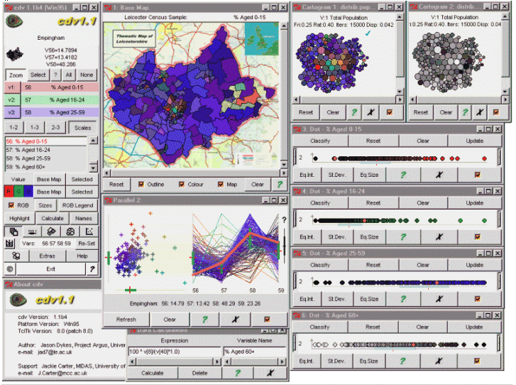
2.2 DescartesSoftware is also being developed to allow this approach to be used within a WWW browser. Links have been established with the German Research Centre for Information Technology (GMD) in Bonn. GMD have written a client-server system, Descartes, in Java which supports some of the cartographic visualization techniques demonstrated in cdv and which can run within a WWW browser. It is hoped that Descartes can be further developed to incorporate additional functionality in order to provide an interactive visualization environment for users of the UK Census of Population.Graphic showing Descartes with Leicestershire 1991 Census data The following graphic shows three views that can be produced from a single census count (here, Cars per Capita). Descartes supports only choropleth and proportionate symbol views to date but has some useful interactive functionality, such as the ability to compare easily any data value to a reference value by use of a slider. Thresholding has also been recently introduced into the system enabling outlier values, which may distort or mask information in the resulting views, to be temporarily eliminated from the resulting view. Brushing and dynamic linking has been incorporated as a result of our contact with the group. 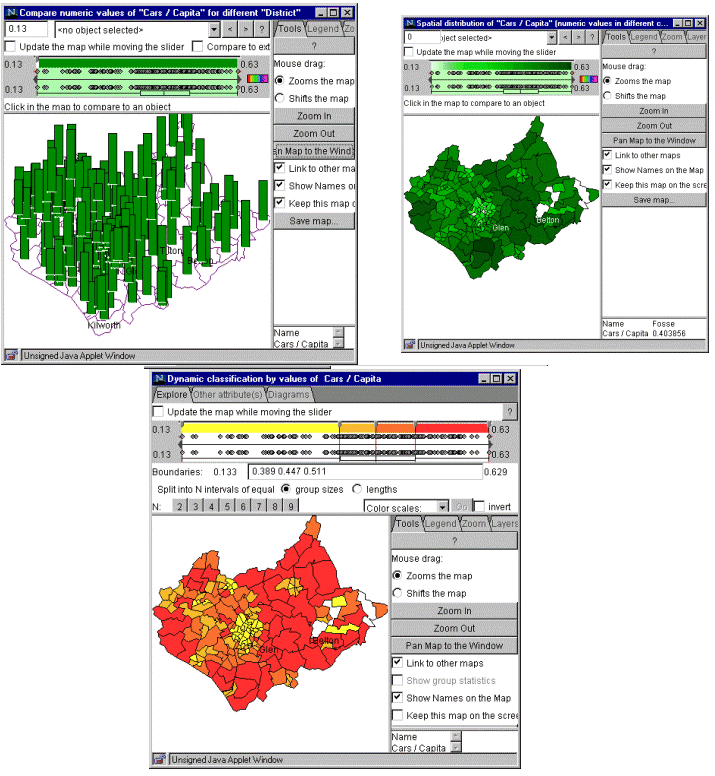
Contact DetailsJackie CarterEmail: j.carter@mcc.ac.uk Data Visualization Support Officer MIDAS Manchester Computing University of Manchester Manchester M13 9PL |
||
Graphics Multimedia Virtual Environments Visualisation Contents