
|
||||


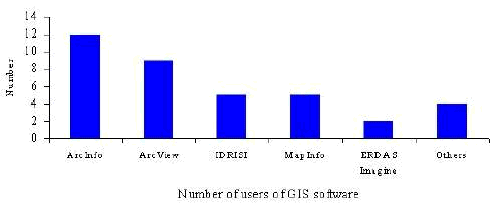
ARCINFO and ARCVIEW were the most popular GIS packages in use based on questionnaire replies - 12 users reported using ARCINFO and a further 10 ARCVIEW. We received reports on the use of IDRISI and Map Info by four users each and two reports on the use of ERDAS IMAGINE. We received just one report on the use of the other GIS software listed below. We have also received comments from ERDAS (UK) Limited on the views of ERDAS IMAGINE posted.
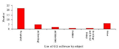
GIS software was used most commonly in geography. Over half of our questionnaire replies in this software group came from geographers working in geography departments. Five users in archaeology reported using GIS software in their work. In other areas of the social sciences the use of GIS technology was rare.
Responses were received for the following software.
ARCINFO
ARCINFO was the most popular GIS package in use in the social sciences. It was either used in research or both teaching and research. Almost universally ARCINFO was regarded as a very useful tool. Equally, it was almost universally regarded as being difficult or very difficult to use.
Specific uses:
ARCVIEW was one of the most popular GIS packages in use. ARCVIEW tended to be used in research or both teaching and research. It was regarded as being either a 'useful' or 'very useful' tool. Views on user-friendliness varied. One respondent felt that the software was very easy to use. The general consensus was that ARCVIEW was fairly difficult to master however. Specific uses of ARCVIEW included:
CDV
CDV was written in TCL by Jason Dykes, as part of the JISC/NTI project. The software runs under Windows 95 or UNIX and was considered to be both very useful and very easy to use. One of the less widely used GIS packages used in both teaching and research. CDV was used for:
ERDAS Imaging A GIS package designed to plan for surface change such as urban development, transport planning and landscape planning.
We received two questionnaires discussing the use of ERDAS Imaging. Both users felt that the software was very useful but fairly difficult to use. One respondent wrote 'Very hard to start off with, but once you have conquered the initial problems it becomes a lot easier.' Specifically ERDAS was used in M.Phil. GIS teaching and Ph.D. research projects.
Applications used included:
We have also received comments from the General Manager of Erdas (UK) Limited, Jonathan Shears, on the views posted. He states that
'ERDAS has been the primary Geographic Imaging software application for the higher education market since it was selected by CHEST in 1993 following an extensive survey by the IUSC Graphics Working Party which was funded by AGOCG. Over 50 universities now use ERDAS IMAGINE for both teaching and research, making it the most popular image processing application for the higher education market. ERDAS have pledged to include all new ERDAS owned software modules in this deal as they become available and recently this has included IMAGINE VirtualGIS - a powerful 3D visualisation tool which is pertinent to this survey, given its wide adoption.' 'Our users tend to be in earth science related applications - typically geography, geology and environmental science, however it is not limited to this . . .'.
In a separate e-mail to the visualisation-tools list Jon states
'It [ERDAS IMAGINE] links very well with ARC/INFO (also available through CHEST) on account of a unique technology exchange agreement between ERDAS and ESRI. Unlike Excel or SPSS, IMAGINE visualises pixel based datasets, rather than information from an underlying database, which is more the domain of GIS applications. As an inherently image based application, IMAGINE's visualisation tools therefore provide image panning, zooming, rotation, geographic linking of multiple windows, image overlay and transparency control for change detection studies.'
ER Mapper
ER Mapper was one of the less frequently used GIS packages. One respondent reported the use of the software in research for satellite image processing. ER Mapper was described as being 'fairly easy' to use and 'quite useful'. Particular advantages were listed as:
A computer cartographic package with the capability in addition to create a range of business graphics. Once widely used. Now it is being superseded by newer software and this is reflected in that only one questionnaire was received making reference to the software. Initially GIMMS would only run on mainframe computers. However, it has now been available for PCs for some time, first running under DOS and later under Windows - but effectively in a DOS window.
The software is not as easy to use or to learn as full windows mapping packages such as ARCVIEW. The command language is complex and it takes some time to become familiar with it. There are some specific problems. On fast PCs a plug-in dongle restricting use of the software under licence may not be recognised. Colour output is fairly poor and the range of fill patterns are very limited. Although a range of text fonts are available text output can be of poor quality. Postscript files are large. Software bugs were also reported
GIMMS was mainly used for creating maps, creating graphics and for the importing and exporting of boundary files.
On the positive side, GIMMS was regarded as largely providing good results with the capability to produce maps rapidly. Once the command language has been learnt it can be flexible. Users are reluctant to give the package up having spent so much time mastering it. In its time it was before its time. Software design has moved on.
IDRISI
An inexpensive raster GIS for introducing GIS concepts to students. Based on our survey results IDRISI was in the 'second division' of GIS packages based on usage. IDRISI was not used as extensively as software such as ARCINFO but it was in more common use than a number of other software packages.
IDRISI was used both in teaching - in GIS and Remote Sensing courses - and in research and consultancy. IDRISI was described as 'Ideal for teaching-conceptually simple'. It was considered to be fairly useful and reasonably easy to use.
The main advantages of IDRISI were listed as:
MapInfo is used fairly extensively for both teaching and research. Whilst most users found the software to be useful a number reported that the software was difficult to use and the documentation poor.
Specifically cited uses included:
We received one brief report on the use of MapMaker in Geography running on Windows NT 3.5
The software was used in both teaching and research for mapping data. Its main advantage was that it could produce accurate maps. However, MapMaker was not as user friendly as it could be. Students had difficulty navigating through menus which were not always logically ordered. There was no database direct linkage internal to the package and output quality was not always satisfactory.
3.2.7 WWW software
The survey highlighted as an area of interest World Wide Web software. We were curious to learn of the use to which the web was being put in the social sciences to assist in visualisation. We expected some general comments on the utility of browsers such and Netscape and Explorer. We further expected mention of the use of static images in the form of gifs (and animated gifs) and JPGs, video technology such and AVI and MPEG, and other technologies such as Java, VMRL etc.
In fact, we received one questionnaire reply making brief mention of the use of Netscape. Amongst most social scientists our findings indicate that the WWW is not important in terms of data visualisation.
Graphics Multimedia Virtual Environments Visualisation Contents