|
||||
| Also available as an Acrobat File | 

|
|
Introduction |
Visual Communication in Urban Planning and Urban Design1. IntroductionNeighbourhoods, cities and regions are complex phenomena (Langendorf, 1992). The way planners and urban designers think about and communicate their ideas about urban problems and their solutions is strongly, although not exclusively, visual. Visualisation of urban planning and urban design is based on three premises Langendorf, 1992):
Communication and visualisation is at the heart of the planning system, the map and plan in two-dimensional form has been the norm, although extensions to the third dimension are important through urban design which acts as the interface between planning and architecture. Other visual media such as photographs and statistical presentations through charts of various kinds also supplement the way such communication takes place. During the last decade, planning has been exposed to new methods of visualisation and some impressive examples have been demonstrated. However, progress has been slow. The culture of computing is alien to the intellectual traditions of planning as indeed it is to much of the social sciences. There are many areas where visualisation can be applied in this field but examples of best practice are rare. However, we sense a burgeoning interest which is now exploding and this is an opportune time to document and critically comment on examples of best practice so that those concerned with introducing the new media to students and researchers are aware of what is useful and possible.
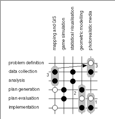
The case studies explored throughout this report are grounded in the various stages of the planning and design process used to prepare plans. These stages involve: problem definition, data collection, analysis, the generation of alternative plans, evaluation, and, finally, implementation. At all these stages. visualisation can be used to communicate to various audiences involved in the process. We can array these stages against the typical technologies which are being developed at present: including desktop mapping and GIS, statistical visualisation, game simulation, 2D and 3D geometric modelling of maps and scenes, and the use of photorealistic media. To broaden the context even further, we will consider visualisation through standalone and networked media, specifically concentrating on visualisation on the World Wide Web (WWW). We can array these items in the following way, see Figure 1. The bold circles indicate areas where quite a lot of work is going on concerning applications of these visual technologies. The open circles are areas in which some work is going on but where such technologies have clear potential. Case studies often span several of these areas. For example, once a GIS or geometric model is built for one stage of the process, it is often easy to use it in another, so that most applications are not restricted to one stage. This Case Study is based on three specific examples:
Each example acts as a separate review of both working examples and software developed within the concept of visual communication in urban planning and urban design. |
Graphics Multimedia Virtual Environments Visualisation Contents