|
||||
| Also available as an Acrobat File | 

|
|
Geometric models |
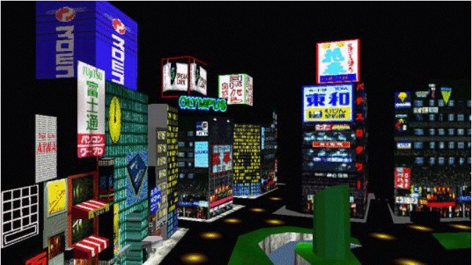
Visual Communication in Urban Planning and Urban Design2. Geometric Models to Demonstrate Alternative Urban Designs2.1 Solid and Geometric ModellingSolid, geometric modelling has traditionally been seated in the domain of specialist Computer Aided Design (CAD), packages running on high end graphics workstations. These packages, whilst often achieving a high degree of realism in modelling urban environments, tend to be limited to operation on single machines running expensive proprietary software, hence restricting access, where available, to fixed problems or planning and design issues. The WWW opens up the ability to distribute these 3D geometric models widely albeit with several caveats. The first major restriction is that models need to be developed in accordance with the limitations imposed by a low bandwidth environment. If dissemination is to be effective, the home user with a modem and line rental charges, should not be overlooked - this effectively means that load times need to be efficient. To achieve a wide user base on the WWW, models need to be developed in a file size of not more than 300 Kb and preferably less than 100Kb. Such a limitation on file size therefore poses the challenge of achieving high levels of realism in a low bandwidth environment. The following sections explore issues which need to be addressed when modelling the built environment on the WWW. The use of Virtual Reality Modelling Language, and other proprietary languages are explored in conjunction with proprietary WWW based modelling software. The potential of each technique for visualising the urban environment is explored with current examples available on the WWW. 2.2 Virtual Reality Modelling LanguageVirtual Reality Modelling Language (VRML) provides the basis for the majority of existing urban models on the WWW. Indeed, VRML is summarised in the introduction to the VRML 1.0 specification as a language for describing interactive simulations - virtual worlds networked via the global Internet and hyper-linked with the World Wide Web (Bell et al., 1993). VRML was conceived in 1993, integrating WWW extensions to Silicon Graphics Open Inventor file format, (Martin & Higgs 1997). The language was designed as an open standard for integrating three dimensional worlds into the Internet. VRML, currently based on specification 2.0 (Moving Worlds), has developed into a de jure standard for the distribution of three dimensional models on the WWW. VRML provides a flexible, cross platform environment to model the urban form. The user is freely able to explore a model and view details from any angle, providing a very flexible way of interpreting any given model using a suitable browser. As VRML is designed for distribution on the WWW, a block model of a large urban environment can potentially occupy less than 100Kb of file space. However, with an increase in complexity, scale and realism of the modelled objects, comes an increase in file size. Furthermore, to achieve realism in terms of being able to identify a polygon as, an "Office Block" or an "Edwardian Terrace" , VRML modellers are sometimes forced to apply textures, or photo-realistic facades to the VRML objects in the model thus increasing file size and down load time. Figure 2 illustrates a VRML model of part of Tokyo, developed by Planet 9 Studios. In this example, the level of realism has been compromised to achieve fluid movement on a home based PC (taken as a Pentium 90 processor) with an acceptable download time i.e. 90 seconds using a standard 28.8 baud modem. Within the virtual scene the end-user is presented with a series of VRML polygons which have had textures added to them as an aid to visual realism.
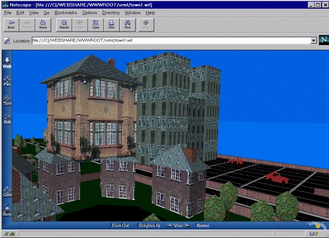
The current release of VRML (VRML 2.0) allows the developer to increase the level of achievable realism by permitting behaviours to be assigned to objects. Behaviours allow a scene to include object movement and directional sound, significantly increasing levels of physical realism and interactivity. Figure 3 illustrates a VRML 2.0 model developed by the authors, showing elements of the VRML environment such as `houses' and `tower blocks'. The basic block model is created and appropriate textures applied to aid user recognition. The model, developed for use in a design education environment, allows the user to move any aspect of the model on the x, y and z axes. The ability to move aspects of the built environment independently of one another, allows each user to create their own interpretation of any given design scenario. The use of VRML 2.0 in this manner is an important step towards the development of Virtual Internet Design Arenas (ViDA's), which will be discussed later. However, as with VRML 1.0, VRML 2.0 is texture dependent and features such as directional sound increase the overall file size and therefore the download time. 2.2.1 Modelling BathIn 1991 the Centre for Advanced Studies in Architecture, University of Bath, received a grant to construct a 3D computer model of the city of Bath. The model, constructed from aerial photographs using photogrammetry, is accurate to less than half a metre and covers the whole historic city centre, an approximate area of 2.5x2.0 km (Bourdakis et al., 1997). The project was supported by Bath City Council and since its completion the model has been used by the city planners to test the visual impact of a number of proposed developments in the city. The model is the most comprehensive in the UK and as such it is useful to explore its development in terms of solid geomatic modelling in relation to the visulisation of urban form on the WWW. The model was developed as separate units based on city blocks with each unit being modelled in a PC based CAD package. Depending on size and complexity, each block took between three and ten days for a skilled operator to construct. The whole model is composed of 150 urban blocks, occupying over 60Mb of disk space (Day, 1994). The Bath model has been converted into VRML to allow viewing on the WWW. Four versions have been developed, to take into account varying technological and design requirements;
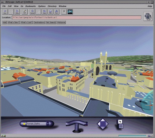
Figure 4 lllustrates a screen shot of the Texture Mapped VRML2.0 version, running on a High end SGI. The textured mapped VRML 2.0 model of Bath is impressive and provides an interesting insight into how the urban environment can be modelled and these models distributed on the WWW. However, at the present time it is not possible to view such detailed models on an entry level home based PC. This is typical of VRML models with visulisation on the WWW limited to basic models. Basic modelling can, however, be used effectively to visualise the urban environment, as a model developed by the Architecture and Building Aids Computer Unit, Strathclyde University (ABACUS) demonstrates.
2.2.2 ABACUS - Modelling GlasgowDuring the 1980's ABACUS developed a model of Glasgow for real time animation on Silicon Graphics machines. The level of detail achieved during the 1980's is now available on the WWW using VRML 1.0. The VRML modelof Glasgow, shown in Figure 5, is divided into separate sectors of the city to reduce file size. Each section of the model is integrated within an innovative WWW browser interface. The ABACUS WWW interface is divided into three separate sections;
The use of windows dynamically linked to the VRML model significantly enhances the users ability to visualise and access information on the urban environment, but the VRML 1.0 models are of limited use because of their low level of detail. |
Graphics Multimedia Virtual Environments Visualisation Contents