|
||||
| Also available as an Acrobat File | 

|
|
Visual Communication |
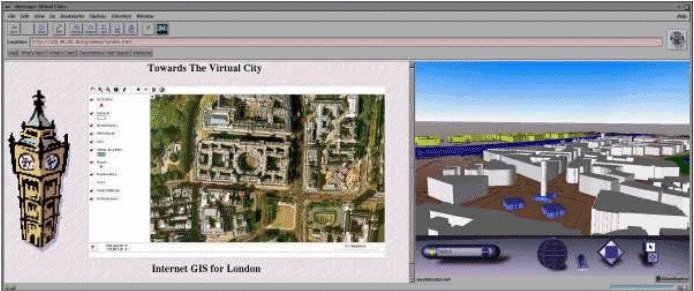
Visual Communication in Urban Planning and Urban Design4. Visual Communication of Planning Data through GISGeographic Information Systems (GIS) applications are powerful graphic "tool-boxes" for the visualisation of spatial data integral to the work of urban planning and urban design. Conventionally GIS uses a two-dimensional cartographic interface to the data on a graphics workstation platform. However, recent developments in the field are greatly increasing the power of the graphic tools to visualise spatial data, as well as again easy access to it. These developments are Desktop GIS, Three-dimensional GIS, and Internet GIS. 4.1 Desktop GISIn the built environment community there has been a steady growth in the use of spatial data to describe features of the built environment. This is due to the rise in sophistication of GIS and the migration of powerful applications from expensive graphics workstations to more widely available desktop PCs. Two of the leading GISs available on the PC desktop are MapInfo (MapInfo Corp.) and ArcView (ESRI). These offer powerful cartographic visualisation tools and are widely used in urban planning. This migration of power to the end user and the increased availability of detailed digital map data has allowed planner and designers to think `spatially' more often in analysing and visualising solutions to built environment problems. 4.2 Three-Dimensional GISThere has been considerable research effort into developing the capabilities of GIS to handle three-dimensional visualisation of the built environment data (Faust 1995). This has often been achieved through the linkage of CAD technologies to a GIS database (Liggett, Friedman & Jepson 1995). More recently there has been interest in using virtual reality techniques to produce 3D solid geometry models that the user can interactively explore and interrogate. The practical implementation of this has been achieved using VRML, with the 3D models being viewed in separate "browser" applications. In this sense, the 3D GIS is created by the "loose coupling" of virtual reality with 2D spatial database. Examples include the research by Martin and Higgs who linked ARC/INFO GIS to VRML to visualise urban property information (Martin & Higgs 1997). Similarly, Smith has created an extension to MapInfo GIS called Pavan which creates VRML models (Smith, S. 1997) and Dodge has developed scripts within ArcView GIS to produce VRML models of small scale urban scenes (Dodge & Jiang 1997). Figure 25 shows this approach of "loose coupling" GIS to VRML.
To create a 3D model from 2D data, four distinct processes are applied. In stage one, the conventional 2D GIS database is used to map the desired spatial information. The user then runs a program or script, usually with in the GIS, that generates a VRML format output from the 2D geometry and attributes. This output is stored in a data file external to the GIS, which is then loaded into a suitable VRML browser for viewing. The browser provides the functionality for the user interactively to explore the 3D model by "walking" and "flying". The user is unable to modify the model in the browser. Modification of the model requires going back to stage one, making changes to the 2D GIS database, and then generating a new VRML model. So there is only a one-way link between the GIS and the VRML, with no means of feedback. Despite this limitation, there are several key benefits to using VRML to produce 3D models from GIS. First, it is a relatively low-cost option in terms of time and money, particularly as the VRML browsers are largely free software. Also the VRML language is an agreed Internet standard and is not proprietary and cross-platform. It is therefore very easy to distribute models to the web community. Many of the commercial GIS vendors are now realising the possibilities of 3D GIS using virtual reality technologies. For example ESRI Inc. will soon be launching a powerful 3D extension to their desktop GIS ArcView (ESRI 1997). This will provide 3D visualisation capabilities within the GIS itself allowing a degree of modelling and analysis in three dimensions. We have mentioned VRML and the ability to employ it by coupling it to GIS. For the benefit of the reader the following section describes VRML and solid and geometric modelling in greater detail. |
Graphics Multimedia Virtual Environments Visualisation Contents