|
||||
| Also available as an Acrobat File | 

|
|
Visual Communication |
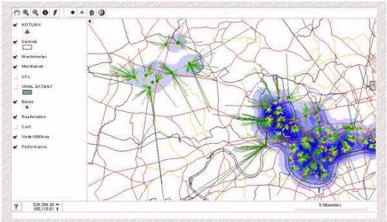
Visual Communication in Urban Planning and Urban Design4.3 Internet GISOn the World-Wide Web, raster images have been used to display two-dimensional cartographic data for a number of years. In fact, in the early days of the Web, one of the first popular interactive services was the Xerox PARC Map Viewer (Putz 1994) which is still available at http://mapweb.parc.xerox.com/map. Whilst these images of maps are useful in certain instances, they offer little of the interactive functionality normally available to the GIS user. This reduces the ability of the end user to interrogate a given set of spatial data. The ability to zoom in and out of a map and to identify objects and be presented with useful attribute data is extremely useful to interested end-users. If, for instance, planning applications were placed `on-line' within a Web site which incorporated an interactive map of an area, interested parties could glean information on previous developments, site or land ownership, contact details in order to voice an opinion, and so on, thus democratising the general process through interactive consultation. To date, two broad types of Web-based interactive mapping solutions have been developed by the commercial GIS vendors: the static map and the dynamic map (Plewe 1997, Toon 1997). 4.3.1 Static MapThis kind of interactive map relies on user input to select a set of variables, which in turn generates a map image at the server side. This map is then returned as a `result' of the user input. In broad terms, the functionality and scope of the graphic user interface (GUI) are reduced in comparison to the dynamic interactive map but the query capabilities are usually more advanced. This kind of application can prove to be more complex for a `public' user to come to terms with if developed at too high a level. ESRI's Map Objects package is a tool box which enables this kind of application to be developed for the web. With competent programming many GIS functions can be created. At ESRI's Web site http://maps.esri.com/ there is a range of these query based applications ranging from a toxin release inventory to a geo-demographic thematic map application. It should be noted that to date the most developed of these applications are US based. This not only reflects the physical location of the major vendors, it also reflects the level of accessibility which exists in the US with reference to digital data and freedom of information. In the UK many similar applications could be built, but for the stifling legal constraints applied to digital data and its dissemination through electronic media. Notwithstanding this, interactive mapping within the browser is a rapid area of development for the GIS community. Anyone who has installed Microsoft's Internet Explorer 4.0 will realise that the desktop is destined to transform itself into a quasi-browser, whereby more and more information and applications will be web enabled or optimised for browser viewing. It seems that the GIS community are moving with the times, this can only be a good thing, not just for the planning community or spatial decision makers, but for the wider geographic information user community with an interest in involving public consultation or the dissemination of information. 4.3.2 Dynamic MapThe Dynamic Map is a basic GIS embedded within a client web browser. The user will typically be able to zoom, pan, identify objects, hotlink to other data and turn layers of data on and off. User actions will be responded to in real time by a map `server', thus giving the `client' or end user a diluted GIS. Within the market place, several GIS vendors have dynamic Internet mapping systems within their product range. ESRI produce MapCafe, Autodesk have Map Guide and Intergraph and MapInfo have their own proprietary applications. Whilst not designed with extensive analytical capabilities these applications are empowering the web community by making spatial data more readily available. The functionality is at a level where pre-determined data may be queried and examined in such a way that the typical end user is not overwhelmed by unfamiliar technology but is still capable of learning about, or contributing to, any given discussion. Figure 26 illustrates an example of a dynamic map which has been developed by the authors. Within the browser, the end user is able to zoom, pan, examine attribute data, switch vector and raster layers on and off and hotlink to related web sites and to multimedia clips. This example is typical of the kind of WWW based mapping which is being developed by GIS vendors. In this instance JAVA is used to serve the map information to the end user. This is advantageous in that any JAVA enabled browser could view the application. Alternative approaches include the use of plug-ins, or applications which are incorporated into browsers. Intergraph's GeoMedia and Autodesk's MapGuide are examples of the plug-in approach. The immediate disadvantage of using a plug-in is that software has to be installed into the browser at the client end prior to data access. This requires some expertise and the appropriate permission to alter the clients configuration. Furthermore many plug-ins are platform or operating system dependent which in turn may restrict the number of possible end users.
The ability to provide two dimensional cartographic or thematic spatial information to the web community is a useful tool and few would dispute the potential of such an approach. Internet GIS will be critical component in the development of virtual cities (Smith 1998) which will enable urban planner and urban designers to visualise and model the complexity of the built environment in networked VR. |
Graphics Multimedia Virtual Environments Visualisation Contents