|
||||
| Also available as an Acrobat File | 

|
|
Contents
Main Report RecentDevelopments Examples Teaching Conclusion Weblinks Bibliographic History |
Review of Visualization in the Social Sciences: BibliographyThe 1970s
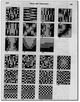
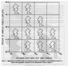
Abler, R (1976) The comparative atlas of America's great cities, selection of variables and cartographic techniques. Proceedings of the Workshop on Automated Cartography and Epidemiology, National Center for Health Statistics, U. S. Department of Health, 52 Alpha, TR and Winter, RE (1971) Quantitative physiographic method of landform portrayal, Canadian Cartographer, 8, (2), 126-136 Andrews, DF (1972) Plots of high-dimensional data, Biometrics, 28, 125-136 Angel, S and Hyman, GM (1972) Transformations and geographic theory, Geographical Analysis, 4, 350-367 Angel, S and Hyman, GM (1976) Urban fields, a geometry of movement for regional science. Pion Limited, London Anscombe, FJ (1973) Graphs in statistical analysis, The American Statistician, 27, (1), 17-21 Applied Urbanetics INC (1971) Reading the map, social characteristics of Washington DC, Metropolitan Bulletin, 6 Arnheim, R (1970) Visual thinking. Faber and Faber Ltd, London Arnheim, R (1976) The perception of maps, The American Cartographer, 3, (1) Bacharch, M (1970) Biproportional matrices and input-output change. University Press, Cambridge Bachi, R (1975) Graphical methods for presenting statistical data, progress and problems. AutoCarto 2 (Proceedings of the International Symposium on Computer-Assisted Cartography), 74-90 Baecker, RM (1973) Computer animation, an aid in visualizing complex processes. Canadian Datasystems, March, 30-32 Barabba, VP (1975) A challenge to cartographers. AutoCarto 2 (Proceedings of the International Symposium on Computer-Assisted Cartography), 15-26 Barb, CE (1974) A spatial display and analysis methodology for monitering urban change. Public Data, 2, (4), 21-27 Bashshur, RL and Shannon, GW and Metzner, CA (1970) The application of three-dimensional analogue models to the distribution of medical care facilities, Medical Care, 8, (5), 395-407 Beddoe, DP (1978) An alternative cartographic method to portray origin-destination data. MA thesis, University of Washington Beniger, JR (1976) Science's "unwritten" history, the development of quantitative and statistical graphics. Abstracts of the Annual Meeting of the American Sociological Association, New York Beniger, JR and Robyn, DL (1978) Quantitative graphics in statistics, a brief history, The American Statistician, 32, (1) Berry, BJL (1971) Problems of data organization and analytical methods in geography, Journal of the American Statistical Association, 66, (335), 510-523 Bertin, J (1978) Theory of communication and theory of 'the graphic', The International Yearbook of Cartography, 18, 118-126 Besag, J (1974) Spatial interaction and the statistical analysis of lattice systems, Journal of the Royal Statistical Society B, 36, (2), 192-225 Bickmore, DP (1975) The relevance of cartography. In J. C. Davies and M. J. McCullagh (eds) Display and Analysis of Spatial Data John Wiley and Sons, London, 328-351 Bloomfield, P (1976) Analysis of cancer mortality in Texas. Proceedings of the Workshop on Automated Cartography and Epidemiology, National Center for Health Statistics, U. S. Department of Health, 27-33 Board, C (1978) How can theories of cartographic communication be used to make maps more effective, The International Yearbook of Cartography, 18, 41-49 Board, C and Buchanan, A (1974) Evaluating thematic maps, current trends in the United Kingdom, The Cartographic Journal, 11, (2), 124-129 Boyle, AR (1974) Geographic information systems in hydrography and oceanography, Canadian Cartographer, 11, (2), 125-141 Brandes, D (1975) Choosing of colour sequences for reproduction in monochrome halftone, The Cartographic Journal, 12, (2), 109-111 Brassel, K (1975) Neighborhood computations for large sets of data points. AutoCarto 2 (Proceedings of the International Symposium on Computer-Assisted Cartography), 337-345 Brassel, K (1977) A survey of cartographic display software, The International Yearbook of Cartography, 17, 60-77 Brassel, KE and Utano, JJ (1979) Design strategies for continuous-tone area mapping, The American Cartographer, 6, (1), 39-50 Brisson, DW (ed., 1978) Hypergraphics, visualizing complex relationships in art, science and technology. AAAS Selected Symposia Series, Westview Press, Colorado Brooks, WD and Pinzke, KG (1971) A computer program for three-dimensional presentation of geographical data, Canadian Cartographer, 8, (2), 110-125 Broome, FR (1976) Techniques for statistical mapping via automation. Proceedings of the Workshop on Automated Cartography and Epidemiology, National Center for Health Statistics, U. S. Department of Health, 67-68 Browne, GS (ed., 1974) Atlas of Europe. Bartholomew and Warne, London Bui-Tuong, P (1975) Illumination for computer generated pictures, Communications of the ACM, 18, (6), 311-317 Bunge, W (1975) Detroit humanly viewed, the American urban present. In R. Abler, D. Janelle, A. Philbrick and J. Sommer (eds) Human Geography in a Shrinking World, Duxbury Press, Massachusetts Bunge, WW (1973) The geography of human survival, Annals of the Association of American Geographers, 63, (3), 275-295 Bunge, WW and Bordessa, R (1975) The Canadian alternative, survival, expeditions and urban change. Department of Geography, Atkinson College, York University, Toronto, Ontario, Canada Bureau of the Census, U.S. (1973) 1970 census of housing, graphic summary of the 1970 housing census. U.S. Department of Commerce, Social and Economic Statistics Administration, Washington DC GPO Burton, CF (1970) Air transportation maps. Proceedings of the International Conference on Transportation Maps, 139-149, Budapest Campbell, RV and Knight, DB (1976) Political territoriality in Canada, a choropleth and isopleth analyses, The Canadian Cartographer, 13, 1-10 Carlstein, T, Parkes, D and Thrift, N (eds, 1978) Timing space and spacing time, human activity and time geography. Vol 2., Edward Arnold, London Carlyle, IP and Carlyle, WJ (1977) The ellipse, a useful cartographic symbol, Canadian Cartographer, 14, (1), 48-58 Carswell, RJB and Wescott, HM (1974) Comparative use of a picture, and written material in social studies, The Cartographic Journal, 11, (2), 122-123 Castner, HW (1971) An Ontario regional development atlas. In H. W. Castner and G. McGraths (eds) Map Design and the Map User, Cartographica, monograph 2, 77-84 Cerny, JW (1972) Ontogenetic and phylogenetic perspectives on cartograms, The Monadnock, 46, 47-52 Chang, KT (1977) Visual estimation of graduated circles, The Canadian Cartographer, 14, (2), 130-138 Chen, KP, Wu, HY, Yeh, CC and Cheng, YJ (1979) Color atlas of cancer mortality by administrative and other classified districts in Taiwan area, 1968-1976. National Science Council, Taupei, Taiwan Chengrui, L (ed., 1987) The Population atlas of China. Oxford University Press, Oxford Chernoff, H (1973) The use of faces to represent points in k-dimensional space graphically, Journal of the American Statistical Association, 68, (342), 361-368 Chernoff, H (1978) Graphical representations as a discipline. In Wang P. C. C. (ed.) Graphical Rep-resentation of Multivariate Data, Academic Press, New York Chernoff, H and Rizvi, MH (1975) Effect on classification error of random permutations of features in representing multivariate data by faces, Journal of the American Statistical Association, 70, (351), 548-554 Chesnais, M (1970) An attempt to map some analytical features of the French railway traffic. Proceedings of the International Conference on Transportation Maps, 101-102, Budapest Chiriin, K (ed., 1977) The national atlas of Japan. Geographical Survey Institute, Tokyo Chrisman, NR (1975) Topological information systems for geographic representation. AutoCarto 2 (Proceedings of the International Symposium on Computer-Assisted Cartography), 346-351 Clark, JW (1977) Time-distance transformations of transportation networks, Geographical Analysis, 9, (2), 195-205 Clarke, JI (1975) Population and scale. Census Research Unit, Working paper 1, University of Durham Clarke, JI (1978) Population geography. Progress in human geography, 2, 163-169 Clarke, JI and Rhind, DW (1975) The relationship between the size of areal units and the characteristics of population structure. Census Research Unit, Working paper 5, University of Durham Clauss, C (1970) Transportation maps for the purposes of agriculture and food-processing industry. Proceedings of the International Conference on Transportation Maps, 121-123, Budapest Cliff, AD and Ord, JK (1975) The choice of a test for spatial autocorrelation. In J. C. Davies and M. J. McCullagh (eds) Display and Analysis of Spatial Data, John Wiley and Sons, London, 54-77 Coombes, MG (1978) Contiguity, analysis of a concept for spatial studies. Discussion Paper 15, CURDS, University of Newcastle upon Tyne Coombes, MG, Dixon, JS, Goddard, JB, Openshaw, S and Taylor, PJ (1978) Towards a more rational consideration of census areal units, daily urban systems in Britain, Environment and Planning A, 10, 1179-1185Coppock, JT (1975) Maps by line printer. In J. C. Davies and M. J. McCullagh (eds) Display and Analysis of Spatial Data, In John Wiley and Sons, London, 137-154 Corbett, JP (1975) Topological principles in cartography. AutoCarto 2 (Proceedings of the International Symposium on Computer-Assisted Cartography), 61-65 Coulson, MR (1977) Political truth and the graphic image, The Canadian Cartographer, 14, (2), 101-111 Coulson, MRC (1978) "Potential for variation", a concept for measuring the significance of variations in size and shape of areal units, Geografiska Annaler, Series B, 60, (1), 48-64 Courgeau, D (1976) Quantitative, demographic, and geographic approaches to internal migration, Environment and Planning A, 8, 261-269 Cox, CW (1975) Psychophysical research and map reading analysis. AutoCarto 2 (Proceedings of the International Symposium on Computer-Assisted Cartography), 233-237 Cox, CW (1976) Anchor effects and the estimation of graduated circles and squares, The American Cartographer, 3, (1), 65-74 Cox, LH (1975) Applications of lattice theory to automated coding and decoding. AutoCarto 2 (Proceedings of the International Symposium on Computer-Assisted Cartography), 519-522 Crawley, BG (1975) Automatic contouring on the Gestalt Photomapper, testing and evaluation. American Society of Photogrammetry. Proceedings of Orthophoto Workshop III, San Antonio, Texas, 1-11 Cuff, D (1972) Value versus chroma in color schemes on quantitative maps, Canadian Cartographer, 9, (2), 134-140 Cuff, DJ (1974) Impending conflict in color guidelines for maps of statistical surfaces, Canadian Cartographer, 11, (1), 54-58 Cuff, DJ (1975) Conflicting goals in choosing colors for quantitative maps. AutoCarto 2 (Proceedings of the International Symposium on Computer-Assisted Cartography), 286-288 Cuff, DJ and Bieri, KR (1979) Ratios and absolute amounts conveyed by a stepped statistical surface, The American Cartographer, 6, (2), 157-168 Dale, L (1971) Cartographic representation of journey-to-work movements. 1971 Canadian Census, working paper (Demographic and Socio-economic Series), 8, Statistics Canada, Ottawa Dalton, J, Billingsley, J, Quann, J and Bracken, P (1979) Interactive color map displays of domestic information, ACM Computer Graphics, 13, (2), 226-233 Dangermond, J (1976) A classification of alternative automated mapping techniques. Proceedings of the Workshop on Automated Cartography and Epidemiology, National Center for Health Statistics, U. S. Department of Health, 34-42 Davis, JC (1975) Contouring algorithms. AutoCarto 2 (Proceedings of the International Symposium on Computer-Assisted Cartography), 352-359 Davis, PJ (1974) Visual geometry, computer graphics and theorems of perceived type. Proceedings of Symposia in Applied Mathematics Vol. 20, The Influence of Computing on Mathematical Research and education, American Mathematical Society. Providence, Rhode Island Dean, AG (1976) Population-based spot maps, an epidemiologic technique, American Journal of Public Health, 66, (10), 988-989 Degani, A (1971) Towards an automated atlas of populaton. PhD thesis, University of Minnesota Denes, A (1979) Isometric systems in isotropic space, map projections, from the study of distortions series 1973-1979. Visual Studies Workshop Press, New York Dent, BD (1972) A note on the importance of shape in cartogram communication, The Journal of Geography, 71, (7), 393-401 Dent, BD (1972) Visual organization and thematic map communication, Association of American Geographers, 62, 79-93 Dent, BD (1975) Communication aspects of value-by-area cartograms, The American Cartographer, 2, (2), 154-168 Dent, BD (1977) The nature of maps, essays toward understanding maps and mapping (review), The American Cartographer, 4, (2), 174-176 Dickinson, GC (1973) Statistical mapping and the presentation of statistics. Edward Arnold, London Dixon, O (1979) A map of population distribution in the Portsmouth area, The Cartographic Journal, 16, (1) Dixon, OM (1972) Methods and progress in choropleth mapping of population density, The Cartographic Journal, 9, (1), 19-29 Dobson, MW (1974) Refining legend values for proportional circle maps, Canadian Cartographer, 11, (1), 45-53 Dobson, MW (1975) Symbol-subject matter relationships in thematic cartography, The Canadian Cartographer, 12, (1), 52-67 Dobson, MW (1975) The map, in the mind's eye. AutoCarto 2 (Proceedings of the International Symposium on Computer-Assisted Cartography), 225-231 Dobson, MW (1979) Visual information processing during cartographic communication, The Cartographic Journal, 16, (1), 14-20 Downs, RM and Stea, D (1977) Maps in minds, reflections on cognitive mapping. Harper and Row Dungan, W (1979) A terrain and cloud computer image generation model, Computer Graphics, 13, (2), 143-147 Dutton, G (1978) American graph fleeting, United States population growth 1790-1970. Laboratory from Computer Graphics and Spatial Analyis, Graduate School of Design, Hardvard University Editura Academiei Republicii Socialiste, Romania (1975) Atlasul republicii socialiste romania. Romanian National Atlas, Romania Eriksson, GA (1970) Methods in traffic planning, the growing demand for transport presupposes traffic planning. Proceedings of the International Conference on Transportation Maps, 25-35, Budapest Evans, D (1973) Keynote address, Why is Computer Graphics Always a Year Away? Computer Graphics, Quarterly report of Siggraph-ACM, 8, (1), 5-11 Everitt, BS (1978) Graphical techniques for multivariate data. Heinemann educational Books, London Ewing, G (1974) Multidimensional scaling and time-space maps, Canadian Geographer, 18, (2), 161-167 Ewing, GO and Wolfe, R (1977) Surface feature interpolation on two-dimensional time-space maps, Environment and Planning A, 9, 429-437 Fabsitz, RR and Feinleib, M (1976) NHLBI mapping project. Proceedings of the Workshop on Automated Cartography and Epidemiology, National Center for Health Statistics, U. S. Department of Health, 69-73 Feinberg, BM and Franklin, CA (1975) Social graphics bibliography. Bureau of Social Science Research, Inc., Washington D. C. Feldman, JJ (1976) Geographic differentials, analytic concerns. Proceedings of the Workshop on Automated Cartography and Epidemiology, National Center for Health Statistics, U. S. Department of Health, 43-47 Fienberg, SE (1979) Graphical methods in statistics, The American Statistician, 33, (4), 165-178 Fisherkeller, M, Friedman, JH and Tukey, J. (1974) PRIM-9, an interactive multidimensional data display and analysis system, American Statistical Association Statistical Graphics Video Lending Library Flannery, JJ (1971) The relative effectiveness of some common graduated point symbols in the presentation of quantitative data, Canadian Cartographer, 8, (2), 96-109 Forbes, J and Robertson, I (1979) Changes in population distribution in Glasgow 1958-1975, Scotish Geographical Magazine, 95, (3), 154-158 Forster, F (1972) Use of a demographic base map for the presentation of areal data in epidemiology. In N. D. McGlashan (ed.) Medical Geography, Techniques and Field Studies, Methuen and Co. Ltd., London Friis, HR (1974) Statistical cartography in the United States prior to 1870 and the role of Joseph C. G. Kennedy and the U.S. census office, The American Cartographer, 1, (2), 131-157 Gatrell, AC (1974) On the complexity of maps. Papers in Geography 11, Department of Geography. Pennsylvania State University Getis, A (1974) Representation of Spatial point pattern processes by polya models. In M. Yeates (ed.) Proceedings of the 1972 meeting of the IGU commission on Quantative Geography, McGill-Queen's University Press Gillard, Q (1979) Places in the news, use of cartograms in introductory geography courses, Journal of Geography, 78, (3), 114-115 Gilmartin, PP (1978) Evaluation of thematic maps Using the semantic differential test, The American Cartographer, 5, (2), 133-139 Gnanadesikan, R (1977) Methods for statistical data analysis of multivariate observations. John Wiley and Sons, New York Groop, RE and Cole, D (1978) Overlapping graduated circles, magnitude estimation and method of portrayal, Canadian Cartographer, 15, (2), 114-122 Guelke, L (1976) Cartographic communication and geographic understanding, Canadian Cartographer, 13, (2), 107-122 Guelke, L (1979) Perception, meaning and cartographic design, Canadian Cartographer, 16, (1), 61-69 Harrell, Allen, T (1978) New methods in social science research, policy sciences and futures research. Praeger Publishers, London Haughton, JP (ed., 1979) Atlas of Ireland. Royal Irish Academy, Dublin Haynes, RM (1978) A note on dimensions and relationships in human geography, Geographical Analysis, 10, (3), 288-293 Herdeg, W (1974) Graphics diagrams, the graphic visualization of abstract text. The Graphics Press, Zurich, Switzerland Hill, GB (1976) Maps of cancer incidence. Proceedings of the Workshop on Automated Cartography and Epidemiology, National Center for Health Statistics, U. S. Department of Health, 48-51 Holly, BP (1978) The problem of scale in time-space research. In T. Carlstein, D. Parkes and N. Thrift (eds) Time and Regional Dynamics, Edward Arnold, London Holmes, JH (1974) Isodemographic map of Canada (review), Cartography, 8, (4), 217-219 Hopps, HC (1972) Display of data with emphasis on the map form, Annals of the New York Aademy of Sciences, 199, 325-334 Howe, GM (1979) Mortality from selected malignant neoplasms in the British Isles, the spatial perspective, Geographical Journal, 145, (3), 401-415 Howe, GM (1979) Statistical and cartographic methods of analysing spatial patterns of mortality, Geoforum, 10, (3), 311-322 Howe, GM (ed., 1970) National atlas of disease mortality in the United Kingdom. Thomas Nelson and sons Hsu, ML (1979) The cartographer's conceptual process and thematic symbolization, The American Cartographer, 6, (2), 117-127 Huggins, W (1973) What's needed now? Why is Computer Graphics Always a Year Away? Computer Graphics, Quarterly report of Siggraph-ACM, 8, (1), 32-48 Hunter, JM and Meade, MS (1971) Population models in the high school, The Journal of Geography, 70, 95-104 Irwin, D (1976) The historical development of terrain representation in American cartography, The International Yearbook of Cartography, 16, 70-83 Jacob, RJK, Egeth, HE and Bevin, W (1976) The face as a data display, Human Factors, 18, (2), 189-200 Jenks, GF (1973) Visual integration in thematic mapping, fact or fiction, The International Yearbook of Cartography, 13, 27-35 Jenks, GF (1974) Statistical mapping and the presentation of statistics (review), The American Cartographer, 1, (2), 175-176 Jenks, GF (1975) Contempory statistical maps, evidence of spatial and graphic ignorance. AutoCarto 2 (Proceedings of the International Symposium on Computer-Assisted Cartography), 51-60 Jenks, GF (1975) The evaluation and prediction of visual clustering in maps symbolized with proportional circles. In J. C. Davies and M. J. McCullagh (eds) Display and Analysis of Spatial Data, John Wiley and Sons, London, 311-327 Jenks, GF (1975) Undergeneralization and figure-ground relationships in statistical mapping. AutoCarto 2 (Proceedings of the International Symposium on Computer-Assisted Cartography), 149-154 Jenks, GF and Caspall, FC (1971) Error on choroplethic maps, definition, measurement, reduction, Annals of the Association of American Geographers, 61, (2), 217-244 Jensen, JR (1978) Three-dimensional choropleth maps, development and aspects of cartographic communication, Canadian Cartographer, 15, (2), 123-141 Johnson, JH, Salt, J and Wood, PA (1974) Housing and the migration of labour in England and Wales. Saxon House/ Lexington Books, England Jonchay, Idu (1970) Long-distance aviation and mass transport. Proceedings of the International Conference on Transportation Maps, 164-165, Budapest Jones, DB (ed., 1972) Oxford economic atlas of the world (4th edition). Oxford University Press, London Kadmon, N (1975) Data-bank derived hyperbolic-scale equitemporal town maps, The International Yearbook of Cartography, 15, 47-54 Kadmon, N (1977) A novel approach to teaching automated thematic cartography, The Canadian Cartographer, 14, (2), 112-119 Kadmon, N and Shlomi, E (1978) A polyfocal projection for statistical surfaces, The Cartographic Journal, 15, (1), 36-41 Kaufman, L (1975) The uses of color. AutoCarto 2 (Proceedings of the International Symposium on Computer-Assisted Cartography), 270-276 Kimerling, AJ (1975) A cartographic study of equal value gray scales for use with screened gray areas, The American Cartographer, 2, (2), 119-127 Kirby, AM and Tarn, D (1976) Some problems of mapping the 1971 census by computer, Environment and Planning A, 8, 507-513 Klawe, JJ (1973) Population mapping, Canadian Cartographer, 10, (1), 44-50 Klove, RC (1975) Census statistical mapping and the users. AutoCarto 2 (Proceedings of the International Symposium on Computer-Assisted Cartography), 175-182 Koeman, C (1979) La graphique et le traitement graphique de l'information, The International Yearbook of Cartography, 19, 159-160 Krause, EF (1975) Taxicab geometry. Addison-Wesley. Philippines Kretschmer, I (1978) The pressing problems of theoretical cartography, International Yearbook of Cartography, 18, 33-39 Kruskal, W (1975) Visions of maps and graphs. AutoCarto 2 (Proceedings of the International Symposium on Computer-Assisted Cartography), 27-36 Leaverton, PE (1976) Automated cartography and epidemiology introduction. Proceedings of the Workshop on Automated Cartography and Epidemiology, National Center for Health Statistics, U. S. Department of Health, 7-8 Lo, CP (1973) Cartographic presentation of three-dimensional urban information, The Cartographic Journal, 10, (2), 77-84 MacEachren, AM (1979) The evolution of thematic cartography, a research methodology and historical review, Canadian Cartographer, 16, (1), 17-33 Machover, C (1973) Future of computer graphics, Why is Computer Graphics Always a Year Away? Computer Graphics, Quarterly report of Siggraph-ACM, 8, (1), 49-63 Marchand, B (1973) Deformation of a transportation surface, Annals of the Association of American Geographers, 63, (4), 507-521 Markova, EE (1970) Utilization of transport maps for regional planning. Proceedings of the International Conference on Transportation Maps, 24, Budapest Masser, I (1976) The design of spatial systems for internal migration analysis, Regional Studies, 10, 39-52 Matthews, GJ (1970) Problems of mapping transportation data in South Onterio. Proceedings of the International Conference on Transportation Maps, 9-16, Budapest McCleary, GF (1975) In pursuit of the map user. AutoCarto 2 (Proceedings of the International Symposium on Computer-Assisted Cartography), 238-250 McGlashan, ND (1977) Dean technique challenged, American Journal of Public Health, 67, (4), 380-381 McKay, FW (1976) Automated cartography for cancer research. Proceedings of the Workshop on Automated Cartography and Epidemiology, National Center for Health Statistics, U. S. Department of Health, 9-17 McKay, RW (1975) A holographic solution to the problem of three-dimensional display in thematic cartography. MA thesis, Department of Geography, Michigan State University Meihoefer, HJ (1973) The visual perception of the circle in thematic maps, experimental results, Canadian Cartographer, 10, (1), 63-84 Meine, KH (1979) Thematic mapping, present and future capabilities, World Cartography, 15 Meyer, M.A, Broome, FR, and Schweitzer, RH (1975) Color statistical mapping by the US bureau of the census, The American Cartographer, 2, (2), 100-117 Moellering, H (1973) The automated mapping of traffic crashes, Surveying and Mapping, 33, 467-477 Moellering, H (1975) Interactive cartography. AutoCarto 2 (Proceedings of the International Symposium on Computer-Assisted Cartography), 415-421 Monmonier, MS (1974) Measures of pattern complexity for choroplethic maps, The American Cartographer, 1, (2), 159-169 Monmonier, MS (1975) Class intervals to enhance the visual correlation of choropleth maps, Canadian Cartographer, 12, (2), 161-178 Monmonier, MS (1976) Modifying objective functions and constraints for maximizing visual correspondence of choroplethic maps, Canadian Cartographer, 13, (1), 21-34 Monmonier, MS (1977) Maps, distortion and meaning. The Association of American Geographers, Resource paper, No. 75-4 Monmonier, MS (1977) Nonlinear reprojection to reduce the congestion of symbols on thematic maps, The Canadian Cartographer, 14, (1), 35-47 Monmonier, MS (1978) Modifications of the choropleth technique to communicate correlation, The International Yearbook of Cartography, 18, 143-158 Monmonier, MS (1978) Viewing azimuth and map clarity, Annals of the Association of American Geographers, 68, (2), 180-195 Monmonier, MS (1979) An alternative isomorphism for mapping correlation, The International Yearbook of Cartography, 19, 77-89 Morrill, RL (1970) The shape of diffusion in space and time, Economic Geography, 46, 259-268 Morrison, A (1970) Maps of road travel speed. Proceedings of the International Conference on Transportation Maps, Budapest, 38-53 Morrison, A (1971) Experimental maps of road travel speed, Cartographic Journal, 8, 115-132 Morrison, JL (1975) Map generalization, theory, practice and economics. AutoCarto 2 (Proceedings of the International Symposium on Computer-Assisted Cartography), 99-122 Muehrcke, P (1972) Thematic cartography. Resource Paper 19, Association of American Geographers, Washington Muehrcke, PC (1978) Map use, reading, analysis, and interpretation. JP Publications, Madison, Wisconsin Muller, JC (1975) Statistical accuracy and map enhancement in choroplethic mapping. AutoCarto 2 (Proceedings of the International Symposium on Computer-Assisted Cartography), 136-148 Muller, JC (1976) Number of classes and choropleth pattern characteristics, The American Cartographer, 3, (2), 169-175 Muller, JC (1978) The mapping of travel time in Edmonton, Alberta, Canadian Geographer, 22, (3), 195-210 Muller, JC (1979) Perception of continuosly shaded maps, Annals of the Association of American Geographers, 69, (2), 240-249 Muller, JC and Honsaker, JL (1978) Choropleth map production by facsimile, The Cartographic Journal, 15, (1), 14-19 Newman, W (1973) Where are we? Why is Computer Graphics Always a Year Away? Computer Graphics, Quarterly report of Siggraph-ACM, 8, (1), 12-31 O'Keefe, JA and Greenberg, A (1977) A note on the van der Grinten projection of the whole earth onto a circular disk, The American Cartographer, 4, (2), 127-132 Olson, J (1972) Class interval systems on maps of observed correlated distributions, The Canadian Cartographer, 9, (2), 122-131 Olson, J (1972) The effects of class interval systems on choropleth map correlation, Canadian Cartographer, 9, (1), 44-49 Olson, JM (1975) Autocorrelation and visual map complexity, Annals of the Association of American Geographers, 65, (2), 189-204 Olson, JM (1975) Experience and the improvement of cartographic communication, The Cartographic Journal, 12, (2), 94-108 Olson, JM (1975) The organization of color on two-variable maps. AutoCarto 2 (Proceedings of the International Symposium on Computer-Assisted Cartography), 289-294 Olson, JM (1976) A coordinated approach to map communcation improvement, The American Cartographer, 3, (2), 151-159 Olson, JM (1976) Noncontiguous area cartograms. Professional Geographer, 28, 371-380 Olson, JM (1977) Rescaling dot maps for pattern enhancement, The International Yearbook of Cartography, 17, 125-137 Olson, JM (1979) Cognitive cartographic experimentation, Canadian Cartographer, 16, (1), 34-44 Parkes, DN and Thrift, N (1975) Timing space and spacing time, Environment and Planning A, 7, 651-670 Petchenik, B (1975) Cognition in cartography. AutoCarto 2 (Proceedings of the International Symposium on Computer-Assisted Cartography), 183-193 Petchenik, BB (1979) From place to space, the psychological achievement of thematic mapping, The American Cartographer, 6, (1) Peterson, MA (1979) An evaluation of unclassed crossed-line choropleth mapping, The American Cartographer, 6, (1), 21-37 Peucker, TK (1972) Computer cartography. Association of American Geographers, Washington D. C. Peucker, TK (1975) A theory of the cartographic line. AutoCarto 2 (Proceedings of the International Symposium on Computer-Assisted Cartography), 508-518 Peuker, TK (1972) Computer cartography, a working bibliography. Discussion Paper 12, Department of Geography, University of Toronto Phillips, DJ (1977) The visual effectiveness of flow maps and cartograms. MA thesis, University of Georgia Pipkin, J (1975) The map as an information channel, ignorance before and after looking at a choropleth map, The Canadian Cartographer, 12, (1), 80-82 Population Statistics Division and OPCS (1979) Geographical area units. Population Trends, 15, 16-19 Post, JB (1973) An atlas of fantasy. Mirage Press Ltd, Baltimore Provin, RW (1977) The perception of numerousness on dot maps, The American Cartographer, 4, (2), 111-125 Ratajski, L and Siwek, J (1977) Regular density network, The International Yearbook of Cartography, 17, 138-154 Reichman, S (1970) Transport mapping in Israel. Proceedings of the International Conference on Transportation Maps, Budapest, 190-200 Rhind, D (1975) Geographical analysis and mapping of the 1971 UK census data. Census Research Unit, Working paper 3, University of Durham Rhind, D (1975) Mapping the 1971 census by computer. Population Trends, 2 Rhind, D (1975) The reform of areal units, Area, 7, (1) Rhind, D (1979) Cartography, topological best-seller, Geographical Magazine, 51, (5) Robinson, A and Petchenik, B (1976) The nature of maps. The University of Chicago Robinson, AH (1974) A new map projection, its development and characteristics, The International Yearbook of Cartography, 14, 145-155 Robinson, AH (1975) Map design. AutoCarto 2 (Proceedings of the International Symposium on Computer-Assisted Cartography), 9-14 Robinson, AH (1977) Research in cartographic design, The American Cartographer, 4, (2), 163-169 Robinson, AH and Petchenik, BB (1975) The map as a communication system, The Cartographic Journal, 12, 7-15 Roessel, JW, van, Langley, PG and Smith, TD (1978) Timber-Pak, a second generation forest management information system. Integrated inventories of Renewable Natural Resources (Proceedings of Workshop), Station General Technical Report, RM-55 Rowles, RA (1978) Perception of perspective block diagrams, The American Cartographer, 5, (1), 31-44 Rowley, G (1973) Landslide by cartogram, The Geographical Magazine, 45, 344 Royston, E (1970) A note on the history of the graphical presentation of data. In E. S. Pearson and M. G. Kendall (eds) Studies in the History of Statistics and Probability, Charles Griffin and Co. Ltd., London, 173-181 Schachter, B (1978) A nonlinear mapping algorithm for large data sets, Computer Graphics and Image Processing, 8, (2), 271-276 Segi, M (1977) Graphic presentation of cancer incidence by site and by area and population. Segi Institute of Cancer Epidemiology, Yomeicho 2-5, Mizuho-ku, Nagoya, 467, Japan Sen, AK (1975) A theorem related to cartograms, American Mathematics Monthly, 82, 382-385 Sen, AK (1976) On a class of map transformations, Geographical Analysis, 8, 23-37 Shepherd, J, Westaway, J and Lee, T (1974) A social atlas of London. Clarendon Press, Oxford Sherman, JC (1975) The challenge of maps for the visually handicapped. AutoCarto 2 (Proceedings of the International Symposium on Computer-Assisted Cartography), 91-98 Shrivastava, VK (1970) Some aspects of the means of representation of lower order transport characteristics in Baghelkhand, Madhya Pradesh, India, a case study. Proceedings of the International Conference on Transportation Maps, 202-209, Budapest Sijmons, K (1978) Hexagonal grid cells for the analysis of mapped phenomena, ITC Journal, 2, 244-262 Skoda, L and Robertson, JC (1972) Isodemographic map of Canada. Geographical Paper 50, Department of the Environment, Ottawa, Canada Slocum, TA and Gilmartin, PP (1979) Cartographic analysis of proportional circle maps using delaunay traingles, Canadian Cartographer, 16, (2), 133-144 Smith, RM (1977) The development of black and white two-variable maps, on-going cartographic research. In H. A. Winters and M. K. Winters (eds) Applications of Geographic Research, Department of Geography, Michigan State University, 145-154 Snyder, JP (1977) A comparison of pseudocylindrical map projections, The American Cartographer, 4, (1), 59-81 Sprunt, BF (1975) Relief representation in automated cartography, an algorithmic approach. In J. C. Davies and M. J. McCullagh (eds) Display and Analysis of Spatial Data, John Wiley and Sons, London, 173-186 Staudhammer, J (1975) Multi-dimensional function display using color scale, Siggraph, 9, (1), 181-183 Steinke, TR (1975) The optimal thematic map reading procedure, some clues provided by eye movement recordings. AutoCarto 2 (Proceedings of the International Symposium on Computer-Assisted Cartography), 214-223 Stutz, FP (1975) Interactive computer cartography, Cartographic Journal, 12, (1), 17-21 Taylor, DRF (1977) Graphic perceptions of language in Ottawa-Hull, Canadian Cartographer, 14, (1), 24-34 Tobler, WR (1970) A computer movie simulating urban growth in the Detroit region, Economic Geography, 46, 234-240 Tobler, WR (1971) A Cappadocian speculation, Nature, 231, 39-41 Tobler, WR (1973) A continuous transformation useful for districting, Annals of the New York Academy of Sciences, 219, 215-220 Tobler, WR (1973) Choropleth maps without class intervals? Geographical Analysis, 3, 262-265 Tobler, WR (1973) The geometry of mental maps. Golledge R. G. and Rushton G. (eds) Spatial Choice and Spatial Behavior, Ohio State University Press, Columbus, 69-81 Tobler, WR (1975) Linear operators applied to areal data. In J. C. Davies and M. J. McCullagh (eds) Display and Analysis of Spatial Data, John Wiley and Sons, London, 14-37 Tobler, WR (1975) Mathematical map models. AutoCarto 2 (Proceedings of the International Symposium on Computer-Assisted Cartography), 66-73 Tobler, WR (1976) Analytical cartography, The American Cartographer, 3, (1), 21-31 Tobler, WR (1976) Cartograms and cartosplines. Proceedings of the Workshop on Automated Cartography and Epidemiology, National Center for Health Statistics, U. S. Department of Health, 53-58 Tobler, WR (1977) A transformational view of cartography. In U. A. Uotila (ed.) The Changing World of Geodetic Science, Report 250, Department of Geodetic Science, University of Ohio State Tobler, WR (1978) A proposal for an equal area map of the entire world on Mercator's projection, The American Cartographer, 5, (2), 149-154 Tobler, WR (1979) A transformational view of cartography, The American Cartographer, 6, (2), 101-106 Tobler, WR (1979) Cellular geography. In S. Gale and G. Olsson (eds) Philsophy in Geography, D. Reidel Publishing Co. Holland, 379-386 Truran, HC (1975) A practical guide to statistical maps and diagrams. Heinemann, London Tukey, JW (1973) Some thoughts on alternagraphic displays, Department of Statistics, Princeton University, Technical Report 45, Series 2 Tukey, JW (1976) Statistical mapping, what should not be plotted. Proceedings of the Workshop on Automated Cartography and Epidemiology, National Center for Health Statistics, U. S. Department of Health, 18-22 Visvalingam, M (1975) Storage of the 1971 UK census data, some technical considerations. Census Research Unit, Working paper 4, University of Durham Wainer, H and Reiser, M (1976) Assessing the efficacy of visual displays. American Statistical Association. Proceedings of the Social Statistics Section, No1, 89-92 Wang, PCC (ed., 1978) Graphical representation of multivariate data. Academic Press, New York Warantz, W (1975) The pattern of patterns, current problems of sources of future solutions. In R. Abler, D. Janelle, A. Philbrick and J. Sommer (eds) Human Geography in a Shrinking World, Duxbury Press, Massachusetts Ward, K (1979) Cartography in the round, the orthographic projection, The Cartographic Journal, 16, (2), 104-116 Warntz, W (1976) A note on surfaces and paths and applications to geographical problems. In S. Angel and G. M. Hyman (eds) Urban Fields. Pion Limited, London, 121-134 Warntz, WW (1973) First variations on the theme, cartographics is to geographical science as graphics is to science generally, Applied geography and the human environment, 2, 54-85 White, RR (1972) Probability maps of leukaemia mortalities in England and Wales. In N. D. McGlashan (ed.) Medical Geography, Techniques and Field Studies, Methuen and Co. Ltd., London, chapter 13 Wilkie, RW (1976) Maps and cartograms, Statistical abstracts of Latin America, 17 Wilkie, RW (1977) Population cartograms and political subdivisions, Latin American populations in the 1970s, Statistical abstracts of Latin America 18 Williams, AV (1978) Interactive cartogram production on a microprocessor graphics system. Proceedings of the American Congress on Surveying and Mapping, Fall Technical Meeting, Albuquerque, New Mexico, 426-431 Williams, LG (1971) Obtaining information from displays with discrete elements. In H. W. Castner and G. McGraths (eds) Map Design and the Map User, Cartographica, monograph 2, 29-34 Williams, RL (1976) The misuse of area in mapping census-type numbers, Historical Methods Newsletter, 9, (4), 213-216 Wong, W (1972) Principles of two-dimensional design. Van Nostrand Reinhold, New York Wood, M (1979) Maps, distortion and meaning (review), The American Cartographer, 6, (1), 83-84 World Bank (1979) World atlas of the child. The World Bank, Washington D.C. Worth, C (1978) Determining a vertical scale for graphical representations of three-dimensional surfaces, The Cartographic Journal, 15, (2), 86-92 Worth, C (1978) The construction of computer produced views of three-dimensional data. Graduate Geography School Discussion Paper 67, London School of economics and Political Science
The 1970s: some key authors
|
Graphics Multimedia Virtual Environments Visualisation Contents