
|
||||
| Also available as an Acrobat File | 

|
|
Contents
Main Report RecentDevelopments Examples Conclusion Weblinks |
Review of Visualization in the Social SciencesPlanningSimilar to geography, planning also has had a long association with computer visualization. Lower platform costs, higher performance and better software applications have bought visualization technology within reach of most planning departments and urban design consultants (Wiggins & Ferreira, 1992). In a study by Levy (1995), the role of computer aided design (CAD) as a visualization tool in the planning process was critically assessed. The findings highlighted the role of such visualization technology in expanding the range of alternative planning proposals under consideration. Furthermore, a study by Bengtsson et al. (1996) indicated that computer-supported modelling and visualization eventually may serve as a common and efficient language, facilitating communication about multifaceted environmental planning issues. In particular, computer animation was discovered to be a more effective and preferable medium of communication than more established methods, such as paper drawings, when concerning dynamic planning issues (Bengtsson et al., 1997). As a consequence, computer simulation techniques may represent an accurate means of reviewing design guidelines, whether proposed or in place, and offers the prospect of significantly opening up planning processes to public view which would have previously been restricted to professionals (Decker, 1994)More importantly, planning has taken full advantage of advances in 3D graphics, VR and the Web. The principle research on the Web in this area concerns Virtual Worlds, and their role in visualising urban forms within multi-user environments. Virtual Worlds is a cheaper and less sophisticated variant of VR. It does not involve the creation of a 3D model of reality within which the viewer is `immersed', but instead uses linked images to produce a `through the window' navigable scene. The use of perspectives and user navigation allows an adequate impression of the spatial extent and a virtual environment in as much detail as it is possible to produce. Furthermore, since it does not require specialised interface devices, such as VR helmets, Virtual Worlds can be displayed on most modern PCs. 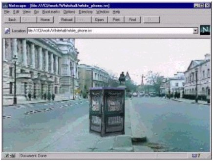 Figure 3 A number of Virtual World `show cases' have been made available on the Web [26, 73], and these are mainly related to relatively small scale urban planning databases. An example of this is the 3D model of the City of Bath, which has been developed to assess the visual impact of new planning applications (Day, 1992). The system uses hyperlinks to couple the 3D model to other related databases. Another example of the visualization and modelling of small scale urban environments using Web based VR techniques is the current research undertaken in the Centre for Advanced Spatial Analysis (CASA) as part of their Virtual Internet Design Arena (ViDA) initiative [18]. A virtual world has been constructed within a photorealistic representation of the real world. The user is able to pan around the virtual world in real time, is able to place a piece of street furniture, such as a telephone box, anywhere within the scene (Figure 3). Within a North American context, similar research can be found on the MIT Department of Urban Studies and Planning website [73]. There, several examples of how emerging information and web technologies can improve the processing and communication of planning-related information in metropolitan planning organisations are presented. These include demonstrations of how to deliver spatially-referenced multimedia material for site planning and reviews using Washington DC, South Boston Seaport and Boston's waterfront development as case studies. Such multimedia interfaces, coupled with the accessibility of the Web, has the possibility of opening up a new paradigm within urban design; one which helps to communicate ideas and developments to other agencies and the general public (Shiffer, 1995). These projects also illustrate the importance of making GIS relevant to urban design. In fact, the evolution of Web GIS is seen as a critical component in the development of virtual cities (Carver, 1997). New visualization and VR technologies have made it possible to display pictures in a GIS, to run animation based on abstract maps as well as video clips and photorealistic VR panoramas, and to link such media to many of the data and functions of the GIS. For instance, 3D visualization capabilities can be added to ArcView by using VRML and custom written Avenue scripts [47]. This has been explored in the VENUE (Virtual Environments for Urban Environments) project [47], which has linked standard GIS and RS packages to urban design packages in an exploration of 3D modelling requirements of urban designers. The project developed around several UK-based case studies - Wolverhampton, Oxford and Central London - to act demonstrators of the range of detailed digital data that is becoming available to urban designers. A wide range of conventional spatial data has been assembled in the GIS, along with multimedia and VR type data. The pictures below give you a flavour of the data assembled for the case study in central Wolverhampton. The building block outlines for the central area of Wolverhampton are shown in 2D in ArcView. The circular polygon around the outside is Wolverhampton's ring road (Figure 4), whilst Figure 5 shows a view of the GIS in Live3D (viewed in the Netscape Web browser)  Figure 4 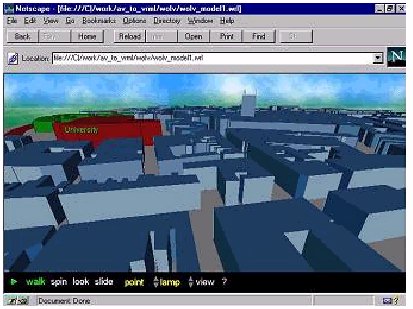 Figure 5 Therefore, the use of GIS and web-based VR technologies has significant potential as visualization tools for adaptation in the planning and design arena. As these powerful software visualization tools become widely available on the Web, the potential exists to undertake networked urban planning and design, which may be particularly applicable to widening public consultation and participation in development projects (Smith & Dodge 1997). |
Graphics Multimedia Virtual Environments Visualisation Contents